Today the River Deveron comes under Banff Bridge and heads in a fairly straight line out into Banff Bay. But over the centuries it’s course has varied considerably. By the early-1800’s it turned left as it reached the Bay and took a course northwest towards where the Pumping Station is today below Banff Castle. Between this leg and the Bay, coming out from the Macduff side, from what is today called Palmer Cove, was a great big shingle bank call the “Bar of Banff”. By the 1860’s it had taken an even more westerly course, so that it ran close to the back of Greenbanks, and right round what is today the seawall along Deveronside.
Today, the name Deveronside is perhaps applicable, but in the nineteenth century it was called Low Shore; Deveronside might have been more applicable back then! This picture at the turn of the century shows the Bar of Banff in the centre, with the river to the left, and “Low Shore” just above centre.
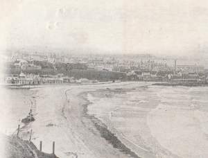
1903 photo of Bar of Banff
This map was surveyed in 1902, and clearly shows the route of the river as in the picture.
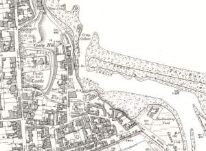
1902 OS map of Banff, extract. With kind permission of NLS.
On this map the Ship Inn, earlier the Ship Tavern, is clearly named. Just south of this there is another building, built mid-nineteenth century, which used to be the Seaview Temperance Hotel. Today what was the Seaview is a rather unloved looking building, built of red sandstone and weathering away.
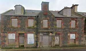
Seaview Temperance Hotel recent view
But the Seaview Temperance Hotel nearly had a much earlier end to it’s life – in March 1906. A huge storm hit the Moray Firth coast. The waves rode right over the Bar of Banff and were crashing against Banff Bridge. On the west side, Low Shore, the waves were running over the top of the wall, breaking windows and flooding all the properties, some of them to over a foot in depth. Added to this the river was in spate and was having to turn round a tight bend to get to the sea. By half past nine on Saturday 17th March morning the sea wall could not withstand the pressure and started to collapse. Over the next three and a half hours nearly 30 yards of the seawall had gone, and 9 to 10 feet of the roadway. As the storm decreased, the tide was rising, and this fortunately slowed the spate of the river.
An attempt was made to divert the river by creating a channel through the Bar of Banff at the Macduff end, but this did little to alleviate the flow at Banff Low Shore.
At the time it became quite a sight, and as this 1906 photo shows, crowds later came to view the damage. The Seaview Temperance Hotel is the building to the left.
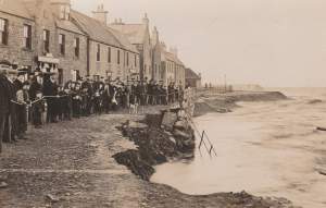
17th March 1906 Low Shore
The storm took away most of the Bar of Banff allowing the river to go back to a course it had taken most of a hundred years earlier on a more northwesterly path. The rest of the Bar of Banff was taken away in 1942 for the building of the Boyndie Aerodrome.

