This Story was written while looking out the window at a wet and windy day. Almost 149 years ago to the day, there was an even worse storm, described nationally as a hurricane.
A Banff eyewitness described it as “Most awful rough day, a real hurricane and raining too”.
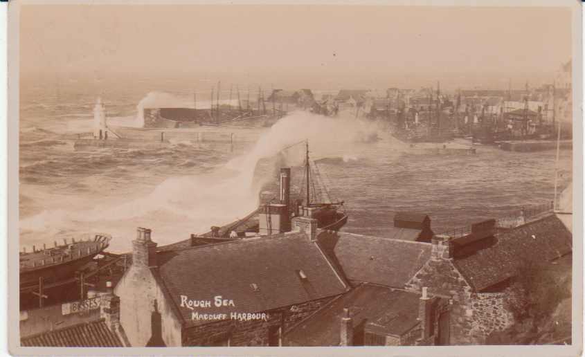
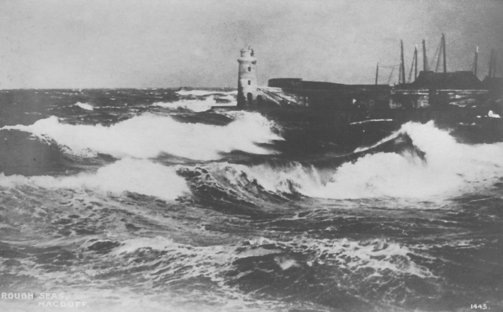
Early 20th cent. rough sea at Macduff Harbour
This photo was taken after 1903 (when the Macduff Harbour lighthouse was put in its present position) but does show a rather rough sea, something that most people in Banff and Macduff will have seen!
The Banffshire Journal reports “the gale commenced very suddenly, about nine o’clock. The wind had been from the south, and, in a very short time, veered round to west-north-west. The sea was very disturbed, and the rain and spray, blown from the crests of the waves, shortened the range of vision seawards.”
Various damages were reported. It was apparently difficult to walk outside, but also unsafe to walk the streets due to the “quantity of slates falling off the roofs of houses”. Various chimney cans were thrown down, and some of the older and more exposed houses in Banff were “a good deal damaged”, and many had water damage from the force of the wind pushing rain inside. A number of trees were blown over, especially reported in Duff House woods.
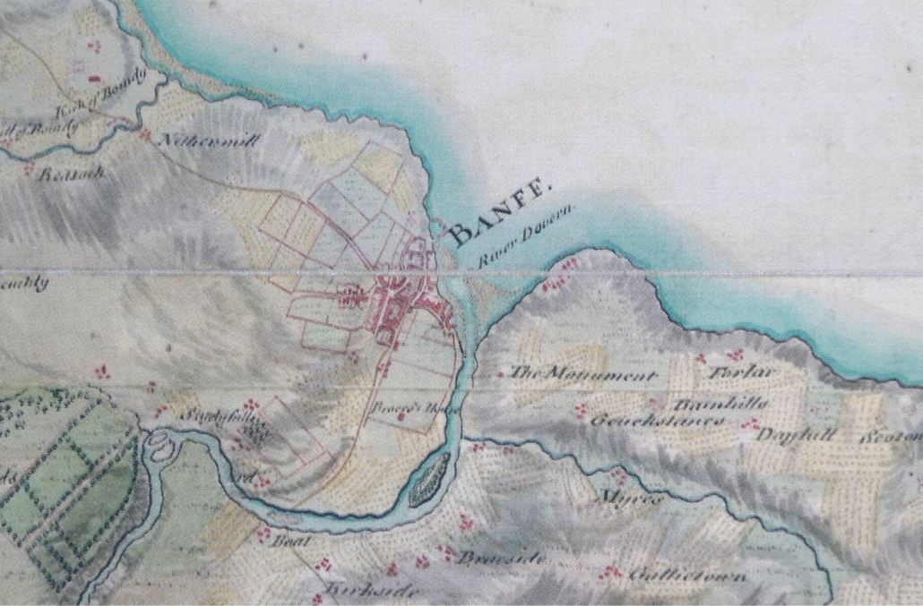
In 1874 the Bar of Banff was still in place, ie the sand and gravel bank sticking out from the Macduff side of the river mouth, and the sheltered area south of it was used for beaching boats. The wind blew over several herring boats that were on Green Banks, but they were not badly damaged. These nineteenth century pictures show the Bar with some herring boats sheltering (there are some just north of Banff Bridge, on the Green Banks side, in the hand water-coloured picture)
19cent. Bar of Banff and herring vessels19th cent. Greenbanks with beached vessels
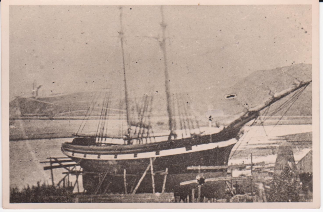
Sometimes of course larger ships like this schooner were beached for repairs, or for building, on Green Banks.
19cent. Clipper beached at Green Banks
From the national newspapers of the time it seems Banff and Macduff did not get the worst of the weather; further south in places there was more substantial damage. It is reported that every telegraph wire north of Birmingham was out of action!
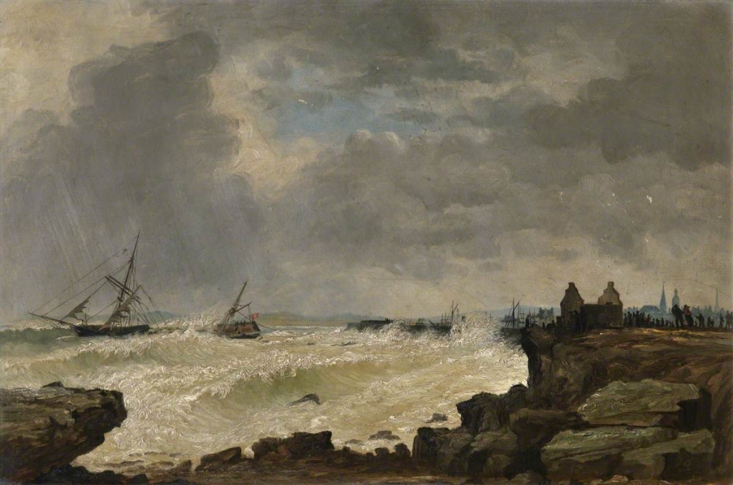
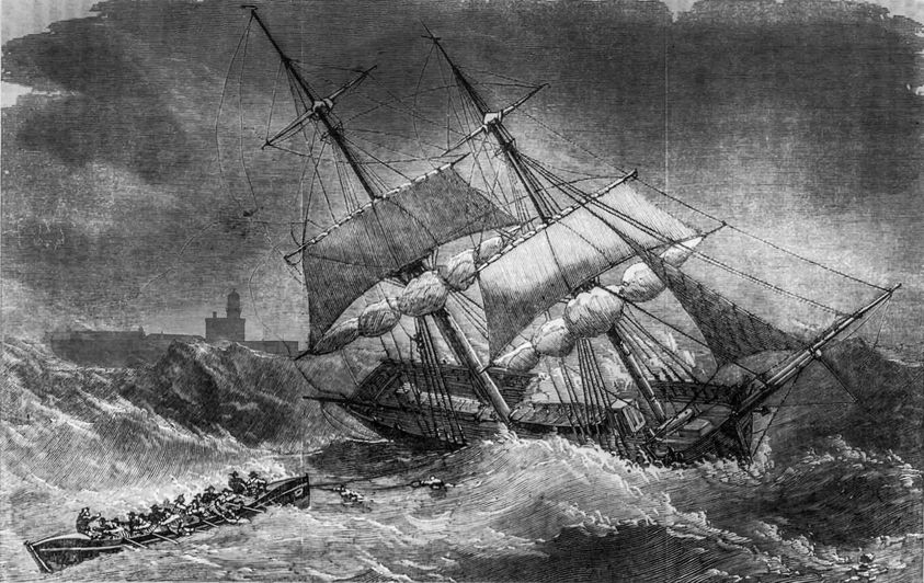
Fraserburgh did have a wreck, of the schooner “Moir”. Her details are not known, but she had sailed from Portsoy with a cargo of oats, bound for Newcastle. But she was blown on to Fraserburgh Sands (just south of the town). Captain James Smith and his crew were saved by the Fraserburgh Lifeboat “Charlotte”. The painting below was done in 1875, the year after, but it is not specified as the “Moir”. The black and white image shows the “Charlotte”, again in action in 1877 for another schooner, the “Fuchsia”, a rescue which saved 4 adults and 4 children.
Shipwreck at Fraserburgh, painted 1875Lifeboat “Charlotte” and clipper “Fuschia”
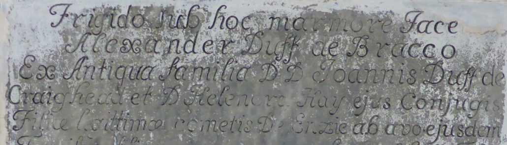
Inside Duff House Mausoleum, one of the memorial stones – now a bit damaged by age – seems to include the word “Antigua”. Some of the wording is very difficult to read so there are no real clues as to what the connection of the Duff family to the Caribbean might be!
Part of the memorial to Alexander Duff of Braco showing “Antigua” (centre left)
In fact this is the Memorial for Alexander Duff of Braco, the uncle of the first Earl Fife. The memorial reads:
“Frigido sub hoc marmore Jace Alexander Duff de Bracco ex antiqua familia D D Joannis Duff de Craighead …..” which translated makes it clear it is nothing to do with the Caribbean!:
“Under this cold marble lies Alexander Duff of Braco of the old family of John Duff of Craighead….”
ie the word is “Antiqua” not “Antigua”, a “q” not a “g”. It certainly isn’t obvious because an upper case A is used, and the q looks almost identical to the g that has been incised except for a small squiggle at the top!
After the 2nd Earl Fife had the Mausoleum built in 1792, initially to house his parents who had first been buried at Rothiemay, before he moved them to the lovely Mausoleum spot above the river, he also moved other relatives. Alexander Duff of Bracco (or Braco) was his great uncle and one of the key members of the Duff family who built up their fortune. He was born in 1652 and died in 1705 and originally buried in Grange, but not before he had bought many estates across north east Scotland.
Alexander is very important in the history of Macduff. In 1699 Alexander purchased “Doune” (ie Macduff after it’s name was changed in 1783). The seller was Lord Cullen – not part of the Seafield family of Cullen House, but Sir Francis Grant, a Scottish Judge who later became Lord of Monymusk.
Alexander Duff of Braco married Margaret Gordon in 1678, and they had four daughters and one son, William of Braco born circa 1685. William died in 1718 with one daughter, also Margaret, so on his death his estate passed to the crown (by way of escheatment, there being no valid direct male descendants). His uncle, William Duff of Dipple, proved he was the male heir and so William of Braco’s estate passed from the Crown to him. William Duff of Dipple was the father of the first Earl Fife. (As an aside to this main story, being family orientated, William Duff of Dipple signed Eden House and estate, just south of Banff, over to Margaret Duff, his nephew’s daughter, so that her future was secure.)
In other words, without Alexander Duff of Braco purchasing Doune/Macduff, it would not have passed via his son and uncle, and in turn to William Duff 1st Earl Fife, who built Duff House, and then to his son James Duff, 2nd Earl Fife. It was James Duff 2nd Earl who developed Doune from being a fishing hamlet to being the town it is today, bringing in craftsmen, building the harbour, the roads, the bridge and much more.
So “Antigua” is not a Caribbean link, but part of the history that has resulted in the great town of Macduff!
For clarity on some of the places:
Craighead was used as an alternative name for Muldavit, today in Rathven (just N or the A98 just before you get to the first Buckie turning from the east). Neither name appears today, but Craig Head on the coast is still named on maps, west of Findochty.
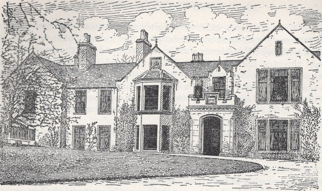
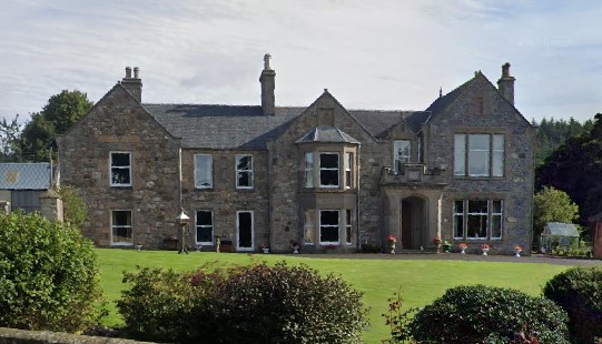
Braco is a place; a farmhouse, in Grange, east of Keith. The “Book of the Duffs” shows Braco in circa 1912 after it had been updated from Alexander Duff’s time, and Google Streetview shows it in 2021.
Braco House in circa 1912 (ex Book of the Duffs)Braco House in 2021 (courtesy of Google Streetview)
Dipple is a place, a farmstead, just south of Fochabers. William of Dipple, who’s son became 1st Earl Fife of Duff House, was a brother to Alexander of Braco.
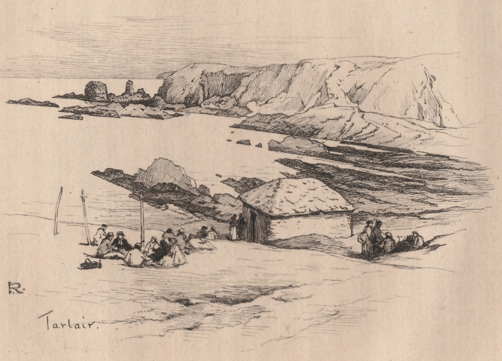
Today Tarlair is known because of it’s Art Deco swimming pool, but long before that Tarlair was still a name known throughout all of the north-east of Scotland and beyond.
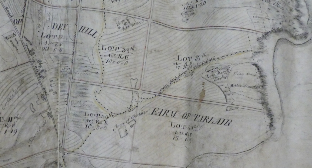
As a name it first appears on a map dated 1600 – essentially a farm steading on part of what is today Royal Tarlair Golf Course; on one map – 1763 – it is called a “town” in it’s own right, with farmlands extending over several lots in Lord Fife’s town planning for Doune – re-named in 1783 as Macduff.
One report claims that the Mineral Springs were “found” in 1740, however, Francis Douglas, a traveller in 1780 wrote that it had only recently been discovered, but already “many people resort in summer” to partake of the waters. The 1763 map is very detailed and identifies two springs in the vicinity, one of which is named as Tarlair “Strype” – a small stream which still exists today. The second spring doesn’t seem to appear on more modern maps.
1763 Map by Hume showing Tarlair
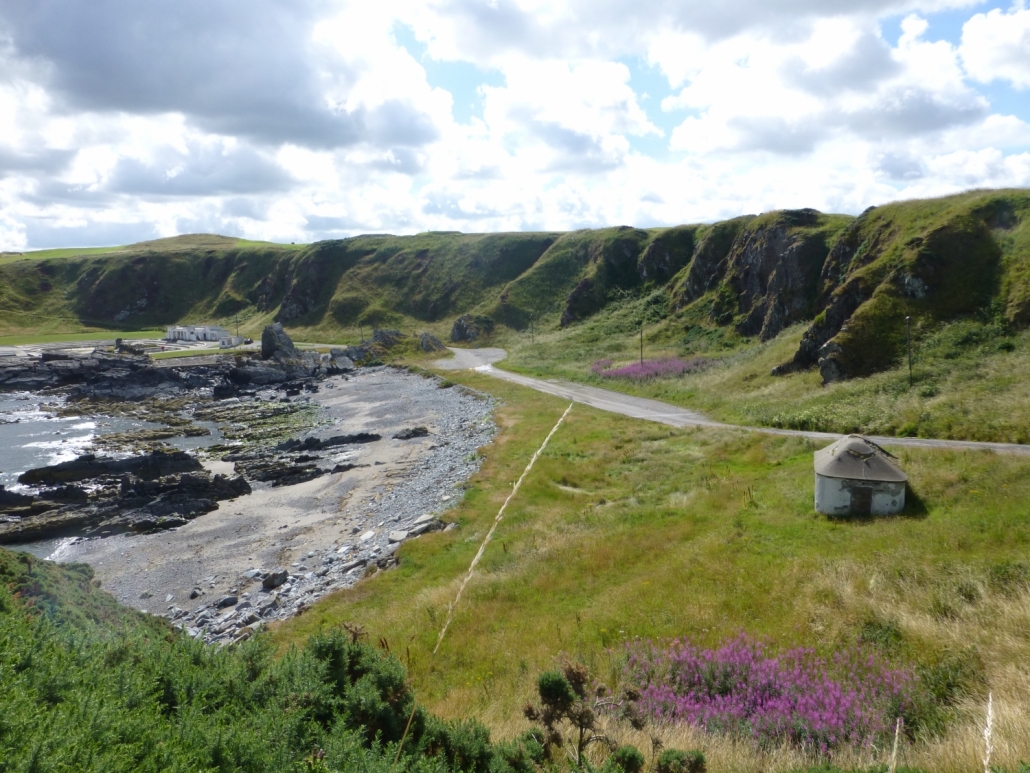
It was only in 1780 that any buildings were built down at the shoreline – one of which can still be seen today. Lord Fife, James Duff the 2nd Earl, whose land the farmstead was on, recognising the popularity of waters, built a small house, and near to it a small croft. The mineral waters were piped – underground – down the slope to the “Well” House, into an iron tank; the building with a stone tiled roof – today partly covered in cement – had wooden benches along the sides and a gutter down the middle, from which water was routed underground to the sea. In truth there was not a “well”, or even a spring at the site, as the water was piped in!
Tarlair Wells House in 2013 showing the swimming pools to the left
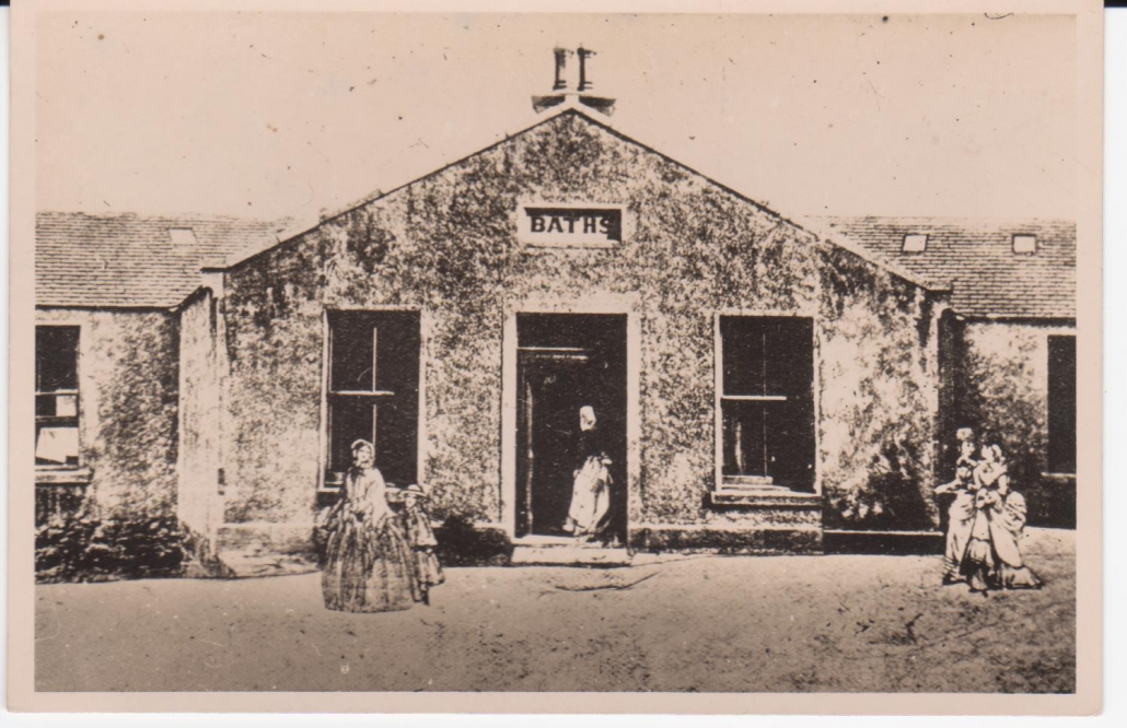
By 1839 according to one local writer, taking the waters at Tarlair was an annual occasion for much of the local population, with some coming much more frequently, due to their “restorative and invigorating virtues”. This was Johnny Gibb, who’s tale was told in the book “Johnny Gibb of Gushetneuk” – a fictional name but real tales. There seemed to be a procedure of drinking at the wells first, as much as could be managed, followed by sea-bathing, ladies nearer the town, men further east, at any convenient point along the coast – although the Macduff Baths (now gone) that were built in 1846 on High Shore provided an alternative, and from 1881 included a swimming pool (Bodie later built new baths in the same location). Even copious amounts of the Moray Firth water would be drunk by some. Others would munch on the “dulse” or “dilse” – seaweed – that grew at Tarlair.
Late 19th century photo of Macduff High Shore Baths
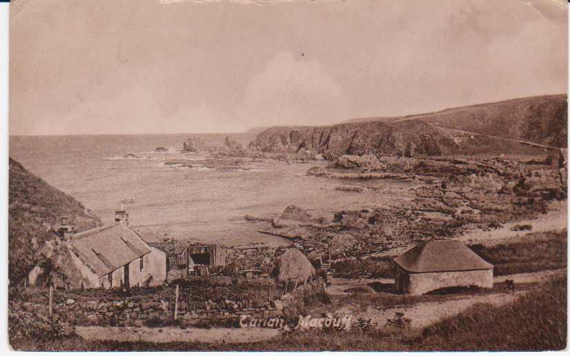
One visitor talks of being able to get some milk, and another being able to get some whisky, as the little croft next to the Well House. Certainly various early twentieth century photos show it was a real working croft.
Tarlair Wells and Croft early twentieth century
It seems that this well, described at various times as medicinal, a spa, health, mineral, chalybeate (meaning mineral springs containing iron salts), had a great reputation and really put Macduff on the map, so to speak. It was extremely popular with many people with innumerable tales of visits, including by whole school classes even coming to Macduff by train, but Tarlair did not have the same facilities as other mineral wells in the area, such as Pannanich Wells at Ballater, which had a dedicated hotel. This meant Pannanich Wells were able to cater to visitors such as the Duff and Garden family, while Tarlair Wells was more for the less affluent. The hotels in Macduff certainly did good trade because of the Tarlair Well – and there are many adverts in all Scottish Papers in the decades each side of 1900 that directly referred to being within 10 minutes of the Tarlair Mineral Wells; one of the main ones was the Temperance Hotel – later known as the Bayview. Carts could be hired to take people to Tarlair, but many people walked and enjoyed the views and coastline.
1880 sketch of Tarlair from “Johnny Gibb of Gushetneuk”
A local writer in 1873 explained that often at Tarlair a variety of occupations would take place: young men would be” improving their strength by hammer or stone [throwing]”; some couples would even be dancing on the green sward near the Wells to fiddle and flute music, others would be just promenading around the Tarlair vale, or many would be resting on the hillside engaged in conversation. At one time the writer heard some people discussing the Darwinian theories – the “Origin of Species” first published in 1859 but only in full in 1869 !. In the second half of the nineteenth century Tarlair Vale was also the rifle practice range for the Macduff Volunteer force (formed 1860), and many north-east Scotland competitions were held there.
In 1929 the building of the swimming pools at Tarlair was approved, first opening in 1931. These soon became a much bigger attraction than the Wells.
On 11th June 1941 it seems that the “Wells” dried up. A local story is that a drifting German mine exploded on the shore – and this may be true but cannot be confirmed as reporting of war events was very restricted. The effect however was that the water supply to the “Wells” stopped. The Burgh engineer concluded that some rocks had moved and broken the pipe at an unknown location. The explosion is also said to have destroyed the croft house. The Wells House was closed up that year and has remained that way ever since as far as is known.
Another linked fact is that in 1996 Sangs, the drinks company on Old Gamrie Road at the time that produced the MacB range of drinks, after a survey, bored 200ft deep within their site to the waters that are said to come from the same source as the Tarlair mineral water; this may be the case based on extending the route of the Tarlair “Strype” which almost cuts across the corner of their site.
Thanks and acknowledgements for this Story go to:
Amy Muir, writing about the Pannanich Wells, hence creating the idea of this Story; The British Newspaper Archive, Banffshire Journal and the Aberdeen Journal; Aberdeen University Library Special Collection and Captain Ramsay.
This continues from the first part of the story posted a week ago.
WILLIAM DUNCAN, 1846-1921 Part 2 of 2
William Duncan was a very enterprising man. He was on various committees and organised the first Masonic Lodges in the Chickasaw Nation. Through his connections as a Scottish Rite Shriner, he heard that the Rock Island Railroad was to be extended and built across his land. He immediately ordered a new store to be built nearer to the railroad site as well as new homes for himself and family members. William had always held the Native Indian people in high regard but ignored their advice not to build his new store in the location he had chosen near the new railway line. They warned him it would be right in the cyclone path but William had already made promises to rail road officials so he went ahead.
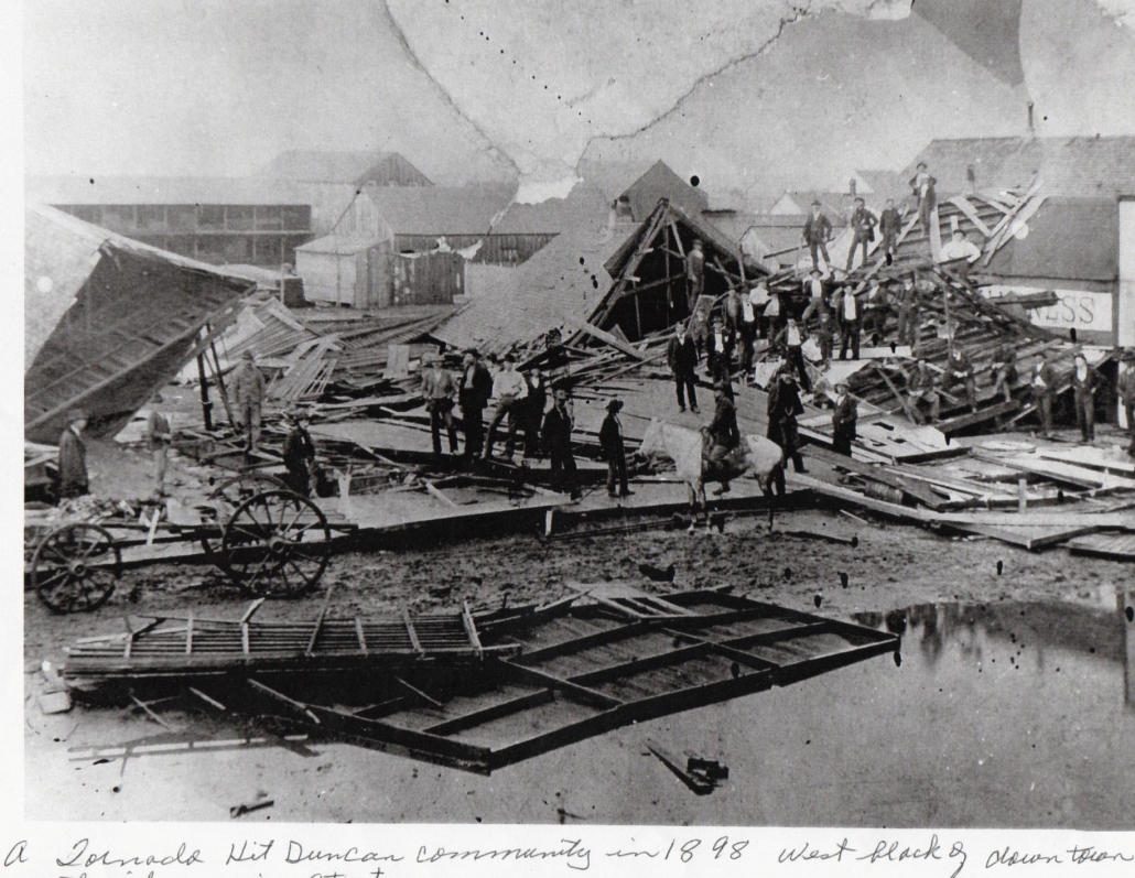
The area was unfortunately struck by cyclones several times over the years with a particularly bad one in 1898 flattening most of the town. The demolished buildings were rebuilt with stronger materials and life went on.
Tornado damage at Duncan, 1898
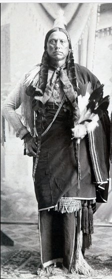
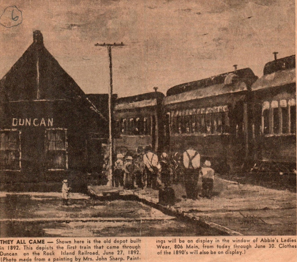
He established ‘city’ limits when other families started to arrive. The town of Duncan was officially named on 27th June 1892 when the first train passed through. By all accounts it was a day of great celebration opening up endless possibilities for the small town, bringing goods and passengers faster than by road and was a mechanical link to the rest of the country. The Duncan band played and there was a party and barbeque which lasted for three days. Chief Quanah Parker, the last Comanche Chief, attended with hundreds of his ‘braves’ from their reservation near Fort Sill, making a colourful sight and a great time was had by all. The anniversary of that day was celebrated for many years after with people coming from miles away in wagons, buggies and on horseback.
Comanche Chief Quanah Parker
1892 Duncan’s first passenger train
1892 was also a sad year for the Duncan family as William’s other two daughters, Ruth and Christina, died of typhoid fever when it swept through the country and they are buried next to their Macduff grandmother, Ann. All three daughters were gone but William still had his three sons, William junior known as ‘Red Bill’, James known as ‘Big Jim’ and Gregg. That same year William ordered the building of the first Baptist Church in ‘Duncan’ which also served as a meeting place. The first school followed soon after.
In 1895, William sold his store, gave up his position as postmaster and concentrated on rearing dairy cattle. William wanted to share his good fortune and encouraged other family members from Scotland to join him. His sister, Isabella Duncan had a large family and two of her daughters, Agnes and Barbara Kelman and a son, Alex Kelman travelled over one by one and made their home there.
Alex Kelman became one of the best known ‘ropers and riders’ at rodeos in the country but tragically died age 40 when he was thrown from his horse. William’s brother James also had two sons, William and Jim Duncan who left Scotland and settled in Duncan, Oklahoma. Out-with his own family, he paid for several other young Scots to travel over, using their skills to help build his town. In return, they settled there and had good lives.
William was described as being cultured, refined and a fine conversationalist, liberal to a fault and never forgetting a friend or those in distress, indulgent to his family and a moral, upstanding man. Mrs Geneva Thurlo, wife of US Marshall Ed Thurlo of the town described William Duncan as being “one of the finest, kindest men I have ever known”.
In 1905, William and Sallie, affectionately known in the town as Uncle Bill and Aunt Sallie, decided to retire due to William’s failing health. They moved, at first, to California to be nearer to son, Jim’s family. Later, they moved again to Bremerton, Washington to be nearer the sea which served as a reminder of William’s homeland. Sallie died there in 1914.
1907 brought statehood to the Indian and Oklahoma Territories and Duncan was made the county seat of Stephens County. It became the 46th state to enter the Union.
William Duncan c1917
In 1919, William and his great niece travelled back to Duncan, Oklahoma for a visit. William did not recognise the place. It was bustling with faces he did not recognise. The population was growing especially since the recent discovery of oil in the region. He suffered a short illness while there and was unable to return home for a few weeks.
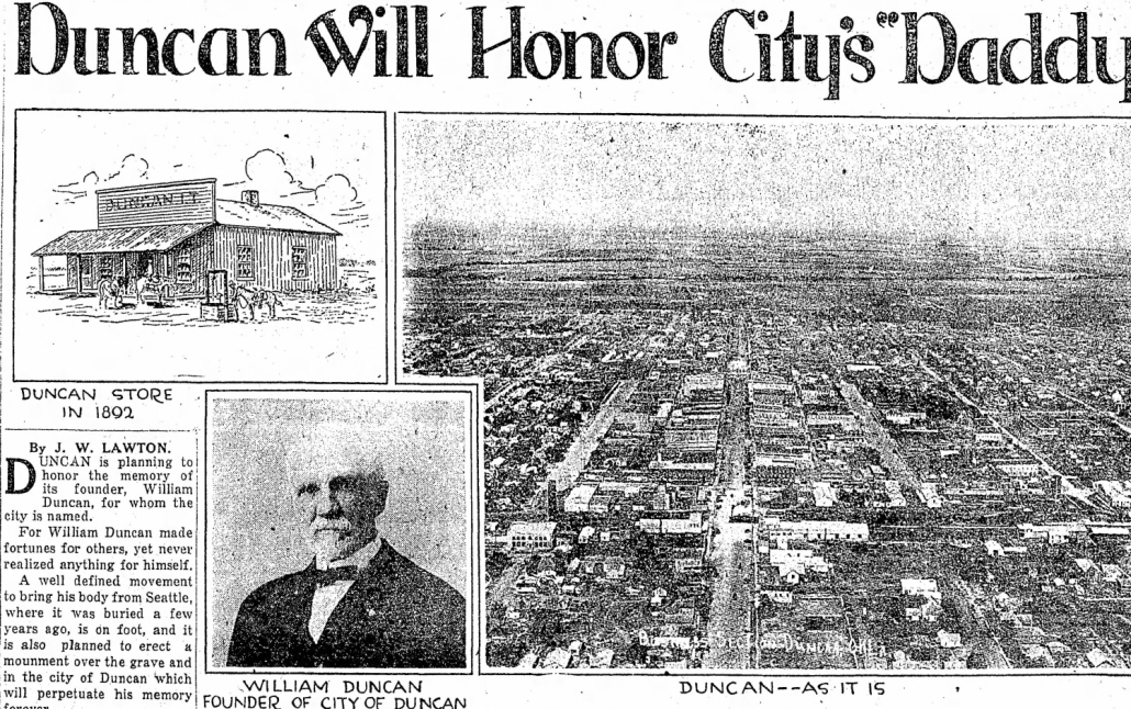
William Duncan died in Bremerton in 1921. His legacy is the town, now a city, which was named after him and the many Scots people who followed him to Oklahoma. There is no statue or memorial for him. There is one for Earle P. Haliburton who founded the oil company based there.
Daily Oklahoma article remembering the founder of the town of Duncan
Note from the author Sonia Packer:
My information has been gathered over many months from descendants of the Duncan family including direct descendants of William Duncan who hold stories and photographs; from archives and news stories; from the Stephens County Historical Museum in Duncan, who have a portrait and personal possessions that belonged to William and from the Oklahoma History site. The Chisholm Trail Heritage Centre is also in Duncan, Oklahoma.
I descend from William’s sister, Annie Duncan who married a farmer and lived in Alvah, Banffshire all her life. William was my 2 x great uncle. William’s mother, Ann Kinnaird was my maternal 3 x great grandmother. Her sister, Helen Kinnaird, who married James Watt, a fisherman from Crovie, Gardenstown was my paternal 2 x great grandmother. Helen’s 2x great grandsons are the founders of Macduff Shipyards.
https://banffmacduffheritagetrail.co.uk/wp-content/uploads/2023/01/221228-1-Main-Street-Duncan-1894.jpg13191695Ian Williamshttps://banffmacduffheritagetrail.co.uk/wp-content/uploads/2024/02/Two-Towns-Big-Ideas-PB-Grant-Fund-Logo-300x281.jpgIan Williams2023-01-09 16:22:292023-01-09 16:22:31MACDUFF - and the WILD WEST - part 2
Everyone has read stories, or seen films, about the Wild West – the American Frontier – as people started moving westwards, populating and developing the land. The “hey day” of this was from the end of the American Civil War in 1865 for about quarter of a century – and right in the middle of that was a Macduff loon…..
We are very grateful to Sonia Packer – born in Banff – for this Story. She is the great great niece of William Duncan, the subject of this absolutely fascinating bit of history.
WILLIAM DUNCAN, 1846-1921 Part 1 of 2
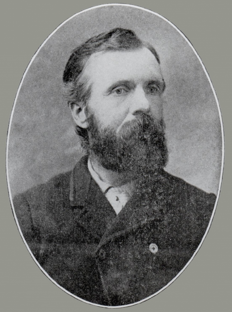
William Duncan was the eldest of ten children born to James Duncan, a dock labourer and cooper who lived in Gellymill Street, Macduff with his wife, Ann Kinnaird who came from a farm in Gamrie.
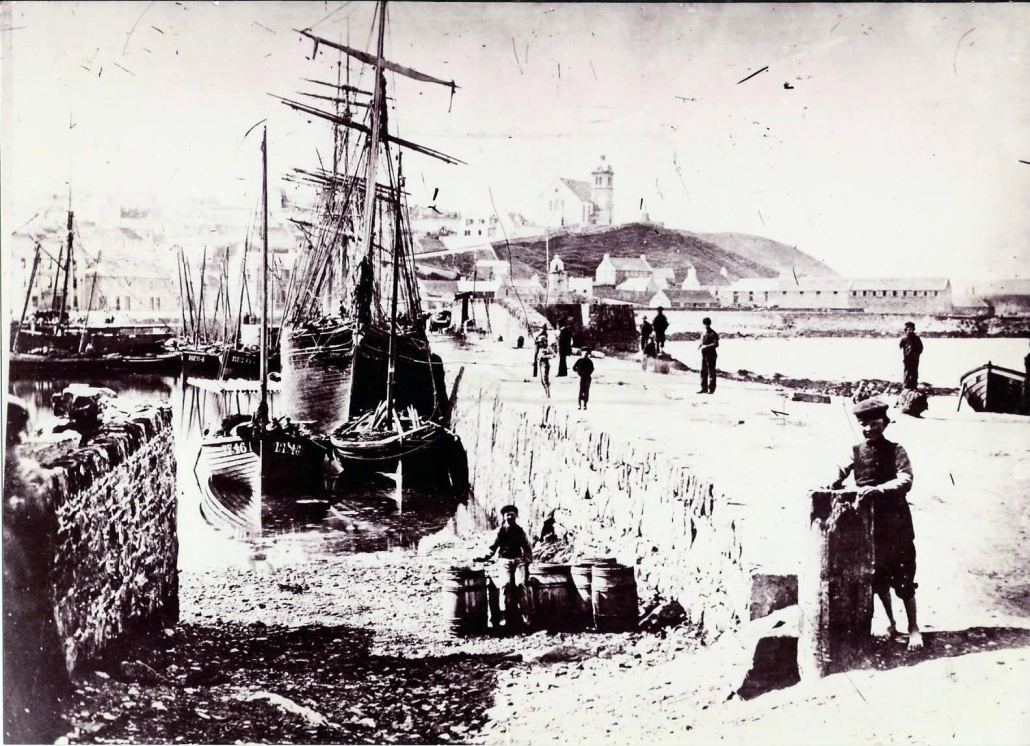
Macduff Harbour circa 1870
William initially worked in Macduff as a tailor. In 1863 he joined the Royal Navy. Not much is known about his experiences in the Navy but it is thought that it triggered his desire to explore the world. In 1866, age 20, William travelled from Glasgow to New York on the SS Caledonia and his new life far away from Scotland began.
At first he worked in any job he could find, gradually moving westward until he landed in Sebastian County, Arkansas. It is believed he used his tailoring skills to make military uniforms at Fort Smith. The whole area was under reconstruction following the end of the Civil War. Soon after, he moved to Stonewall, in the wilds of the Indian Territory, working as a clerk at a trading store and in 1868 he married Martha Patsy Hall. They went on to have three daughters and three sons. Their eldest child, a daughter, died as a baby. Martha died in 1878 following the birth of their sixth child. The following year he married his second wife; Sarah Jane Thornhill, known as Sallie, the widow of a Chickasaw Indian. She was a white girl but had been accepted by the Chickasaw Indians and spoke their language. The family moved to Fort Sill (formerly Camp Wichita) where William again used his tailoring skills. In 1882 William bought a general store at Cow Creek, close to the Chisholm Trail.
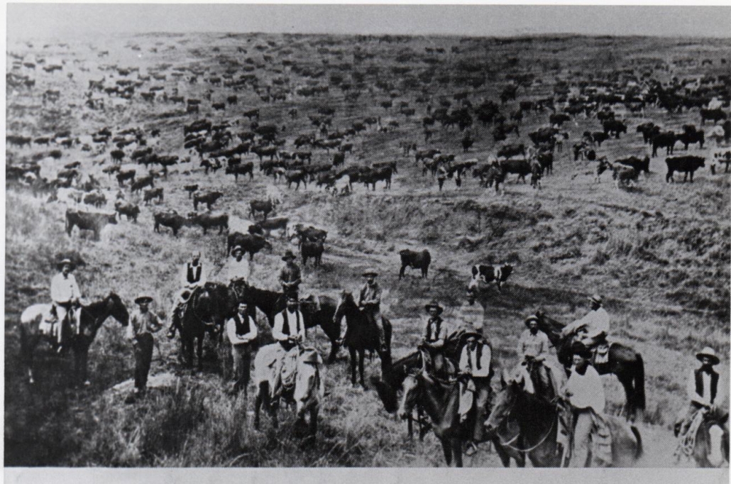
Chisholm Trail cowboys on the Prairie
The trail, named after its developer, Jesse Chisholm, was used to drive longhorn cattle between Texas and the railroad markets at Kansas, so William’s store was ideally positioned to supply trade to the cattle herders/cowboys, ranchers and American Indian people from nearby reservations. The customers at his trading post also included some of the outlaws who used the Territory as a hideout – resulting in some tense moments! Supplies for his store mainly came by freight wagons from Gainesville, Texas.
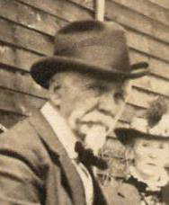
William Duncan in younger years
In 1884, William Duncan was also officially elected as Postmaster, a position he held for 11 years and the Duncan post office was established. As Sallie was legally classed as an ‘intermarried white’, she and William had a right to Indian Territory land so they claimed hundreds of acres surrounding their store. He started to build, expand and lease out areas to be brought to a state of cultivation. Over time, large numbers of people came to settle there and the little town of Duncan became well known. There was plenty of grass and water and the store supplied everything required for farming.
In 1888 William sent money home to Macduff so that his parents and some other family members could come and join him. In March that year their long journey began. The party consisted of James and Ann Duncan, their daughter Barbara with her husband Arthur Horne (his family owned the Crown Temperance Hotel and Stables in Banff and ran the first ‘penny bus’ service between Banff and Macduff) with their young son Joseph. Also in the party was another daughter, Agnes – who was married to Macduff man, Charlie Birnie – and her two young children, William and baby Annabella. The family first travelled by train from Macduff to Glasgow then by ship (the SS Furnessia) to New York, a journey of several weeks. A train from New York took them to Gainesville, Texas where they rested before being transferred by covered wagon to William’s home at Cow Creek. Ann Duncan sadly died there just a few months after their arduous journey.
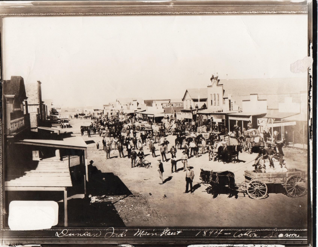
Main Street, Duncan 1894
Agnes Duncan and her husband remained in Oklahoma and raised their large family there. Barbara Duncan and her husband, Arthur Horne returned home to Banff as the pioneer life did not suit them. James Duncan also went home to Scotland shortly after the death of his wife but returned to visit his son, William, in 1895 and they always kept in close contact.
Watch this space for the second part of William Duncan’s development of “his” town of Duncan.
https://banffmacduffheritagetrail.co.uk/wp-content/uploads/2023/01/221228-1-Main-Street-Duncan-1894.jpg13191695Ian Williamshttps://banffmacduffheritagetrail.co.uk/wp-content/uploads/2024/02/Two-Towns-Big-Ideas-PB-Grant-Fund-Logo-300x281.jpgIan Williams2023-01-03 16:36:552023-01-09 16:24:00MACDUFF - and the WILD WEST
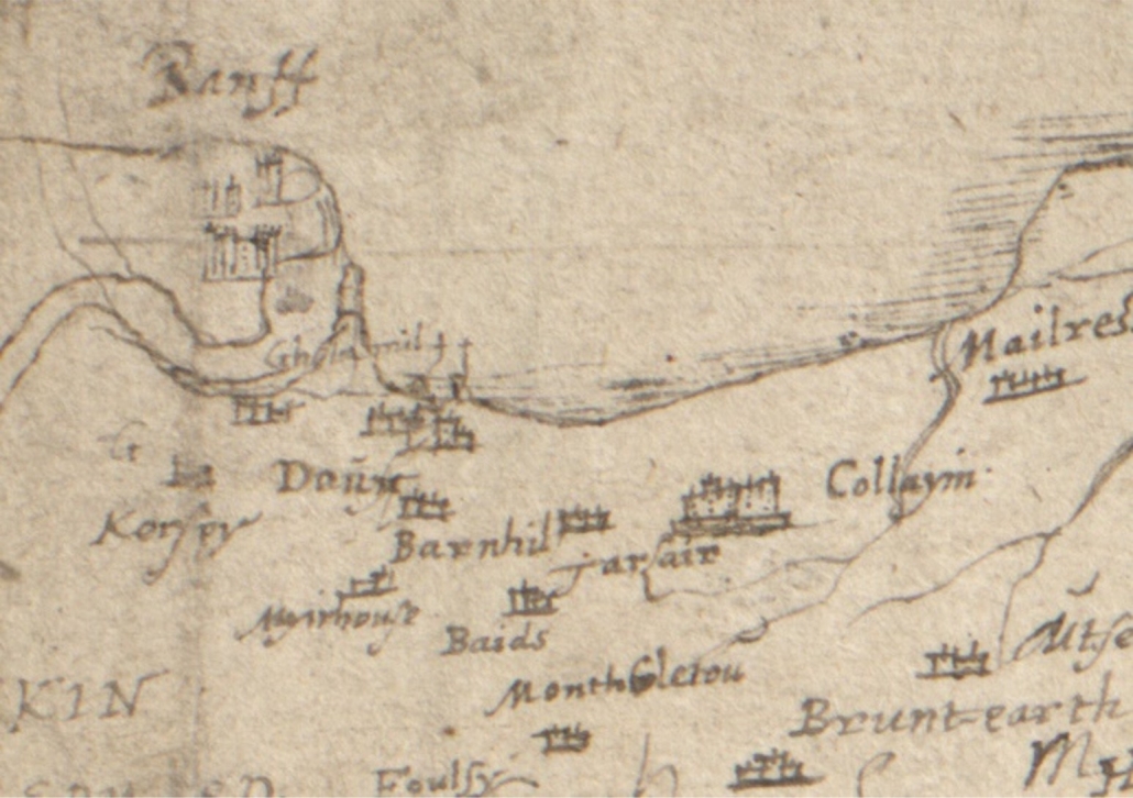
The earliest map that shows any level of detail for Banff or Macduff is dated AD 1600 and names the towns of Banff and Doun, also the settlements of Gellymill, Barnhill and Tarlair. But it also shows the shape of the river mouth, clearly indicating the bar coming from the Doun (Macduff) side. This expanded estuary covers a much larger area than the river does today, and may well have included not just Greenbanks, but the low lying land where Duff House now stands.
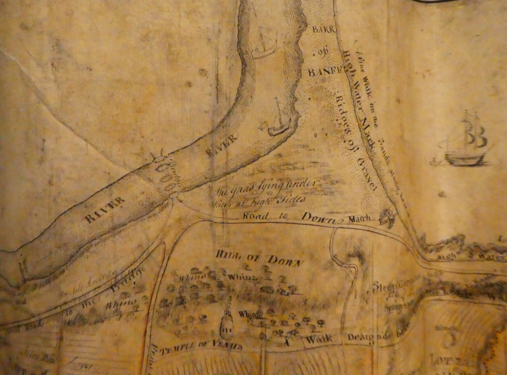
The next image is the first indication of what is a harbour, essentially shared between both Banff and Macduff. Unfortunately it is a century and a half later before there is another map that gives any detail of the area. This is the map produced by General Roy in the aftermath of Culloden, to inform the government of potential routes for it’s army around Scotland. The bar from the Macduff side is clearly still shown, with Greenbanks still submerged. Duff House is now shown (“Braco’s House”) and the Temple of Venus.
The very detailed map of Macduff in 1763 shows not only the shape of the river, but clearly how the river mouth is used by substantial ships (of their day) as a harbour. Interestingly this map also shows the piers of the first Banff Bridge, not reportedly completed until 1765. This map was commissioned as part of the town planning for the new town of Doune – not named as Macduff until 1783.
Note: the next available maps are 1772 and 1775. The former does not show any Banff Bridge, as it had been swept away in 1768. The Taylor & Skinner map of 1775 shows the new Banff Bridge.
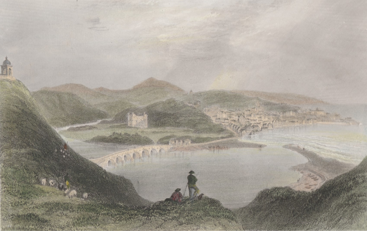
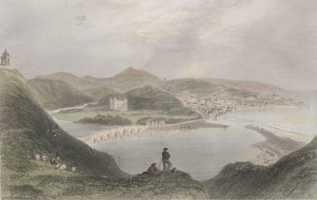
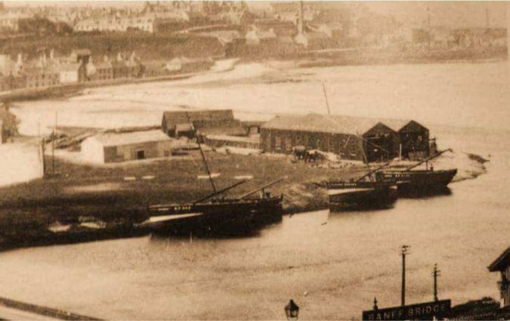
There are also some images which clearly show the estuary, inland of the Bar, being used for shipping. The colour drawing is 1839. The black and white photos are late in the 1800’s. By then there was a shipyard on the Banff side of the river mouth.
https://banffmacduffheritagetrail.co.uk/wp-content/uploads/2022/05/Finden-1839.jpg10711697Ian Williamshttps://banffmacduffheritagetrail.co.uk/wp-content/uploads/2024/02/Two-Towns-Big-Ideas-PB-Grant-Fund-Logo-300x281.jpgIan Williams2022-05-30 22:13:292022-05-30 22:14:52The First Harbour of Macduff
It was just a normal Saturday for me. My mother woke me up in time for my school hockey match – a home game against Fraserburgh Academy. I struggled out of bed and looked sleepily out of the window. Dark clouds were scudding across the sky and rivulets of rain trickled down the windowpane. Not a day for hockey or football but, unless the visiting teams had phoned to cancel the fixture, their hired bus would already be on its thirty mile journey to Banff Academy. I would have to turn up at the school in order to find out.
Standing at the unsheltered bus stop, with the wind whipping around my legs and the rain soaking my thin trench-coat, I was sure that the whole thing would have been called off. But as I rushed up the school brae, I saw, to my horror, a blue Alexander’s bus sitting at the gate. Our opponents had arrived! “The match is off” was the cry, as I staggered into the cloakroom. Our teachers had apparently decided that even we hardy northeast scholars could not be expected to play football and hockey in such weather. That was a relief! The not-so-good news was that there had been no time to cancel our school lunch, which was an integral part of the sporting arrangements in this rural part of the world. After all, we sometimes had to travel forty miles or more to our matches, and a school dinner was part of the deal.
It was probably a mistake to make us hang around just for the sake of a school lunch. But the food had been bought, the cook had arrived and it seemed the sensible thing to do. How were our teachers to know that an extremely deep depression situated off the coast of Norway was rapidly heading our way? Our school hall was completely surrounded by classrooms and, in this cosy cocoon, we entertained our visitors while the meal was being prepared. It wasn’t until we ventured out to the canteen that the full force of the storm hit us. We hastily gobbled up our mince and tatties, gathered our things together and set out for home.
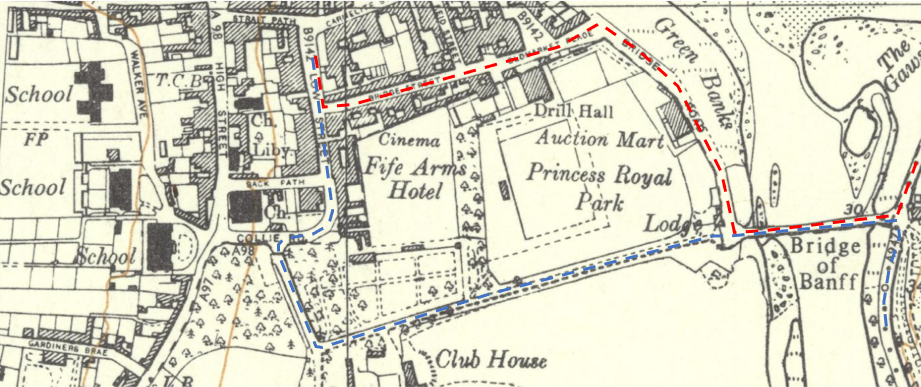
My friend and I raced down to the ‘Plainstones’ to catch the 12 o’clock bus. Wet and windblown, we sank into our seats; but our relief was short-lived. The bus driver didn’t appear to be taking his usual route. The river Deveron had burst its banks, he explained, and he would have to take us through the private grounds of Duff House.
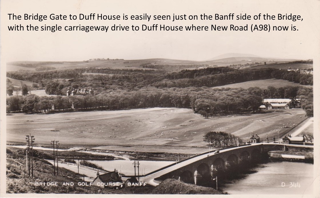
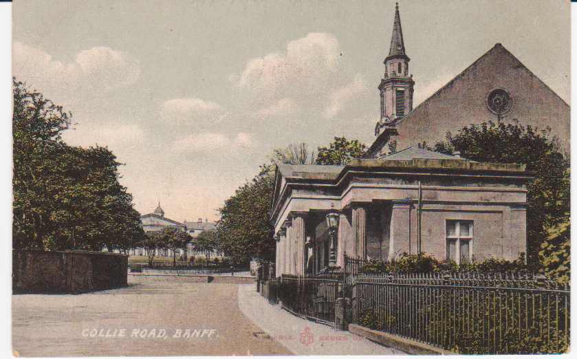
Collie Gate – opposite to Collie Lodge now the cobbles in St Mary’s Car Park – was the entrance into the Duff House estate.
The caretaker at the lodge opened the big wrought-iron gates for us and we headed for the bridge over the already swollen river. We should have turned left along the coast road but huge waves, created by the wind and exceptionally high tide, were crashing over the sea wall and rebounding off the steep hillside at the opposite side of the road.
The blue line being the route the bus took, through the private roads of Duff House, as Bridge St, Bridge Road and Princess Royal Park were underwater!
Instead we turned right along the ‘Howe’, a tree-lined country road popular with Sunday strollers. Not today, though! The wind screeched through the bare branches of the birches, beeches, elms and rowans, bending them over until they were almost horizontal. We crouched in our seats, terrified that, at any moment, a tree might get uprooted and come crashing down on top of us. Once the driver had negotiated the corner at the cemetery, we knew we were out of the woods and that home was only a few minutes away.
My mother wasn’t too surprised when the electricity went off in mid-afternoon. “Power cables”, she said – in a knowledgeable sort of way. At teatime, the gas for the cooker fizzled out as well. Only a few years after my mother had acquired her fancy new domestic appliances, we were plunged back into the middle ages, with only a few candles and a coal fire for comfort. At bedtime, I had to find the way to my attic room in the dark. The wind was still rattling the panes of the dormer window and I pulled the covers over my head to shut it out.
Sunday morning brought a curious calm. Under a pale grey, watery sky, we ventured out to inspect the damage. At the harbour, almost half the town seemed to be staring in bewilderment at a fishing boat sitting lopsidedly in the middle of the street. Further along the road, the sea had completely undermined the foundations of the petrol station, which now dangled precariously on the rocks. And the coastal road, which we should have travelled along the day before, resembled a boulder field.
It is the custom for people to be drawn together at such times, united in commiseration or in simple curiosity. And so, small groups of local folk were dotted here and there along the sea-front, viewing the devastation with disbelief. On our meanderings, we discovered that the gasometer in Banff had been washed into the sea, which explained our lack of gas.
Shows the gasometer that used to be at Banff Harbour.
I also met some of the football boys, who had missed the last bus out of Banff at lunchtime on Saturday. They had apparently decided to walk back home and had been forced to struggle over the Hill O’Doune to escape the rising tide. Crawling on hands and knees, clinging on to bushes and to each other, they managed to avoid being blown away and reached the relative safety of Macduff with nothing more than a few scratches and a thorough soaking.
By evening the electricity supply had been restored but, with no prospect of gas in the forthcoming weeks, my mother’s shiny ‘New World’ cooker now supported a pair of decidedly ‘old world’ Primus stoves. With our immediate needs taken care of, our thoughts now turned to the outside world. We had been cut off from the rest of civilization for two whole days and we had no idea how the rest of Britain had fared.
It was Monday morning before we became aware of the full impact of the storm. Newspapers and radio reported that; in East Anglia, 2,500 square miles of land lay under water and 307 people had perished in the floods at King’s Lynn; one sixth of the Netherlands was also under water with more than 2000 lives lost. In the south-west of Scotland, 133 people had been drowned when the British Rail ferry, Princess Victoria, had sunk in Belfast Lough on her crossing from Stranraer to Larne. Much closer to home, six men of the Fraserburgh lifeboat drowned when their boat was caught by a giant wave and capsized at the harbour mouth. The seas were so fierce that it was impossible for any of the witnesses to enter the sea to rescue them. For us and others around Britain, the forces of nature had taken their toll.
https://banffmacduffheritagetrail.co.uk/wp-content/uploads/2022/02/Feature-image-with-caption.jpg6951119Ian Williamshttps://banffmacduffheritagetrail.co.uk/wp-content/uploads/2024/02/Two-Towns-Big-Ideas-PB-Grant-Fund-Logo-300x281.jpgIan Williams2022-02-07 19:30:102022-02-07 19:30:14The Great Storm 31st Jan 1953
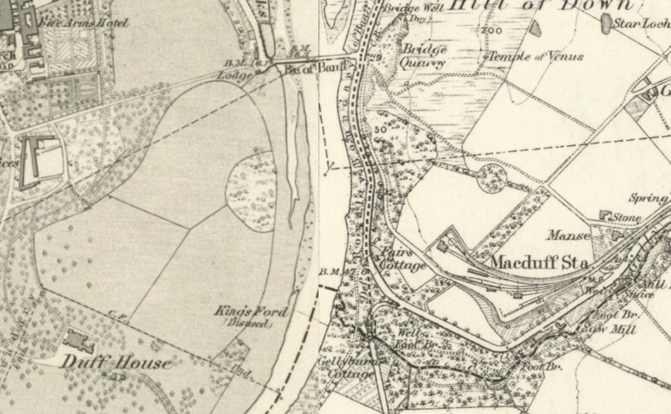
Ordnance Survey maps of ~1870 showing the present Banff Bridge and the King’s Ford
The present Banff Bridge was opened in 1779, although not formally signed off until 17th June 1780. Some of the original drawings of this Smeaton designed bridge, widened in 1881, do exist. Many people are however aware that the present bridge replaced a previous one but little is known about it.
The Roy map of 1747 gives a sketch of both Banff and Down (although the latter is not named) and it does show a ford across the river. This appears to be the King’s Ford, located 1350 feet south of the present bridge, just upstream of the mouth of the Gelly Burn on the Macduff side; part of the track from this ford to Down is still traceable on the ground.
A bit later there was also another ford utilising the west end of Scurry Island – the island just round the first major bend to the south – which joined the track past what is now Kirkside farm.
Use of the fords however was quite difficult and certainly dangerous; the tracks to them were also reported as not easy to navigate in wet weather – or until the 2nd Earl Fife undertook to improve them if the land was passed to him – which only took place in 1777. The alternative was the use of a ferry, but some of the arguments used to make the case for a bridge show how dangerous the ferry was too: “not a single year passed without some unfortunate occurrence at this ferry”; “inconvenience to the public”; “frequent stoppage of mails”. One of the reported incidents was 12th January 1739 when several people lost their lives after the ferry overturned.
The case for a bridge over the river was several decades in the making, and the earliest known detailed map of either Banff or Down (not named Macduff until 1783), dated October 1763, does show the beginnings of the first bridge. This unique map shows the first bridge had three piers in the river, plus one on each bank – hence four arches compared to the present seven arched bridge. It was largely paid for by the Government and is reported to have cost between five and six thousand pounds. It opened in June 1765.
However great it was to stay dry crossing the river – remembering it was the main route to Aberdeen – on 17th September 1768 there was a large storm, and a huge spate of water came down the river. This undermined the west, Banff side, pier, and the bridge collapsed, although fortunately without loss of life.
Unfortunately the ferry that had to be resumed was not so safe; in January 1773 seven lives were lost when the ferry was carried out into Banff Bay.
Smeaton decided that the new bridge should be located “the breadth of itself further up”. Not particularly clear but the 1763 map allows some scale measurements to be taken and it would appear the old bridge was slightly to seaward of the present bridge. The stones from the old bridge were re-used in the new bridge when work started in 1772, much of the rest coming from the quarry now at Bridge garage.
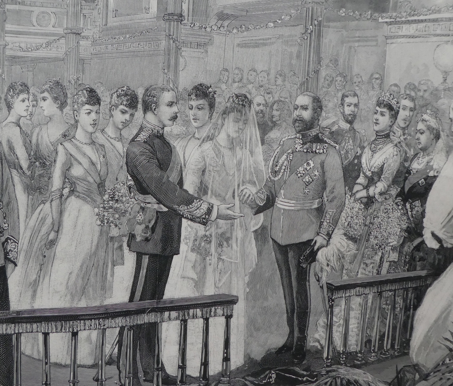
27th July. Louise and Alexander’s marriage service started at noon, 131 years ago today. Quite an auspicious marriage for Banff and Macduff, as Alexander was the Sixth Earl Fife with his main home being Duff House, and Louise was the Princess Royal, the daughter of the then Prince and Princess of Wales. Prince Edward became King Edward VII in 1901.
The ceremony took place in the Private Chapel at Buckingham Palace, attended by most of the British Royal Family as well as royalty from Germany, Denmark and Greece.
In the main picture in this Story, the foreground characters from the left, are some of the seven bridesmaids, Alexander, Louise, Prince Edward of Wales, Princess Alexandra of Wales and Queen Victoria.
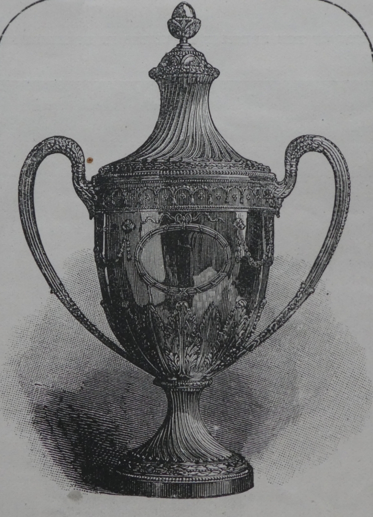
The other photo in this article is a large silver two-handle cup that stands 24 inches high, has an engraved representation of Duff House and the couple’s coat of arms, and bears the inscription “Presented to H.R.H. the Princess Louise of Wales and The Earl of Fife, K.T. on the occasion of their marriage by the Inhabitants of the Royal Burgh of Banff, July 27, 1889”. A very handsome gift indeed.
A commemorative special Illustrated London News was published just four days later, and bearing in mind that this publication at that time did not use photos but hand drawn engravings – and there are sixteen of the actual wedding itself in this edition, one being a double page, and the rest at least half a page – is quite remarkable. Additionally this publication has several dozen engravings of other views, with about a dozen being of Banff and Macduff including Duff House; hence it is a great source for the heritage of the area.
Alexander was first made Duke of Fife and Marquess of Macduff two days later, and, unusually, in 1900 he received a second set of Letters Patent which amended the 1889 ones to allow the Duke’s titles to pass to his and Louise’s daughters Alexandra and Maud, as there was not a male heir.
The 1st Duke of Fife died in 1912 from pleurisy likely as a result of complications from being shipwrecked off the coast of Morocco while on a cruise on the ss Delhi; the rest of his family all survived. Louise, Duchess of Fife is reputed not to have favoured Duff House, and hence the gift of the estate to the people of Banff and Macduff in 1907. She is of course the person behind the name of the sports and community club and making Banff and Macduff the only place in the world with two Royal golf courses. Louise died in 1931, and her remains are with her husband’s in St Ninian’s Chapel at Mar Lodge.
From the people of the Royal Burgh of Banff, silver, stands 24 inches tall.
https://banffmacduffheritagetrail.co.uk/wp-content/uploads/2020/07/wedding-ceremony.jpg12791500Ian Williamshttps://banffmacduffheritagetrail.co.uk/wp-content/uploads/2024/02/Two-Towns-Big-Ideas-PB-Grant-Fund-Logo-300x281.jpgIan Williams2020-07-27 16:23:072020-07-27 16:23:11131 years ago today ...